
PORT GAMBLE — A Kitsap County environmental group wants the county to study building the North Sound to Olympics Trail alongside State Route 104 instead of through the middle of Port Gamble Forest Heritage Park.
The Kitsap Environmental Coalition asked the Board of County Commissioners in a Sept. 29 letter to analyze a separated, paved shared-use path within the highway right of way, largely along the park’s eastern edge, before the county commits to a permanent route. The coalition announced the request publicly Oct. 28.
“This is not a request for the Board to choose SR 104 today,” the letter, signed by coalition President David Onstad, says. “It is a request that the Board make the route decision based on a fair comparison of viable alternatives—before committing the County to a permanent alignment through PGFHP.”
The North Sound to Olympics Trail is the county’s planned walking and biking route linking the Kingston ferry terminal to the Hood Canal Bridge, where it would connect to the Olympic Discovery Trail on the Olympic Peninsula. The county’s preferred alignment uses old logging roads through the 3,493-acre heritage park, the county’s largest.
Trail on hold since 2025
Work on the park segments has been paused since March 2025. The coalition had filed an environmental (SEPA) appeal over a trail segment tied to the new Carver Drive parking lot. To settle it, commissioners adopted a resolution saying the trail would not move forward without further review and analysis and the board’s approval, according to minutes of the county’s Non-Motorized Citizens Advisory Committee. The settlement let the parking lot proceed.
Commissioner Christine Rolfes, whose district includes Port Gamble and Kingston, told the committee in May 2025 that the resolution did not halt work but acknowledged the project’s status, and that the board had funded a Parks Department wildlife habitat study given the project’s scope, according to the minutes.
The county’s 2026-2031 transportation improvement plan pushes construction of the park’s trail segments out to 2029 and 2030. It notes that a federal construction grant was returned in 2024 and that earlier Kitsap Public Facilities District grant approvals are likely no longer available.
Separately, the county signed a contract July 27 to update and finalize the park’s framework, or master plan. According to Parks Advisory Board reports, the update focuses on a wildlife study, trail-user conflicts and park capacity and is expected to run through mid-2027. The coalition wants that scope expanded to include a feasibility study of the SR 104 option.
What the coalition says
The coalition says the highway option has never been properly studied. The county’s 2011 “String of Pearls” trail plan considered SR 104 only as an “on-road improvement,” essentially a wider shoulder, and rejected it. A path separated from traffic, like the one being built along SR 305 on Bainbridge Island, was not evaluated, the group says.
Based on its own preliminary review, the coalition says the west side of SR 104 appears to have room in much of the corridor for a 10-foot path set at least 5 feet from traffic, next to a 40-foot power-line corridor.
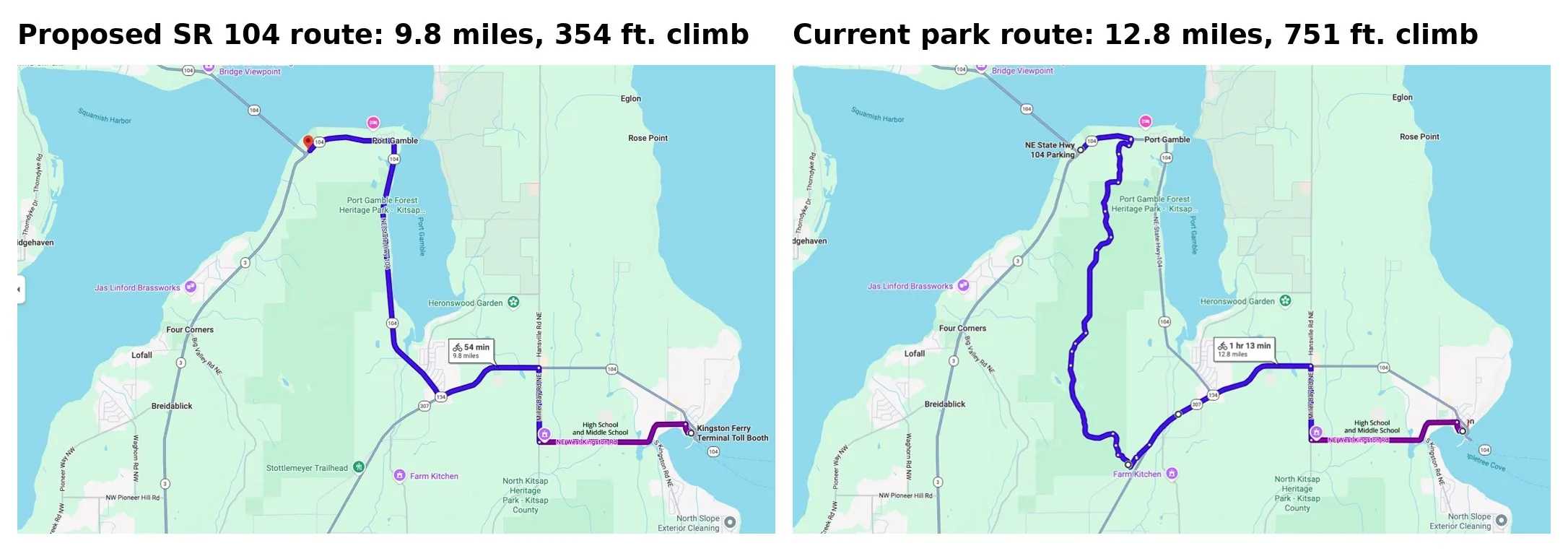
Using Google Maps bike routes between the Kingston ferry and the Hood Canal Bridge, the group compared the two options:
- SR 104 route: about 9.8 miles with 354 feet of elevation gain, following highway grades under 5%.
- Park route: about 12.8 miles with 751 feet of gain, including a stretch of Carver Drive that reaches about a 12% grade.
The coalition also argues that:
- A highway path would better serve as transportation, linking Kingston, Port Gamble, Gamblewood, George’s Corner and Hansville, and by other connections Indianola and Suquamish.
- It could be more competitive for federal active-transportation grants.
- It could cost less. Citing state Department of Transportation planning figures, the group puts comparable paths at about $600,000 to $1.05 million a mile and says park segments have reportedly cost $1 million to $3 million a mile. In 2023, county Public Works said cost estimates for park trail segments A and B had tripled since 2019.
- Stream crossings along SR 104 could be coordinated with planned culvert and salmon-restoration work, including potential projects involving the Port Gamble S’Klallam Tribe.
- Keeping the trail in an existing transportation corridor would avoid cutting a new, heavily used route through recovering forest habitat.
- The park route via Carver Drive bypasses the Port Gamble business district, the Port Gamble S’Klallam Tribe’s shoreline redevelopment and the park’s Bayview trailhead.
The coalition asks that any comparison cover right-of-way, engineering, safety, accessibility, wildlife impacts, stream crossings, construction and maintenance costs, permitting and funding. It says it will keep raising the alternative throughout the planning process.
The coalition is an Indianola-based nonprofit. More information is at kitsapenvironmentalcoalition.org.
Leave a Reply